Bangladesh floods, 1998
The 1998 Bangladeshi floods have been described as some of the most destructive flood in modern times. 80% of the country of Bangladesh is classified as a floodplain, and following heavier than average monsoon rains between July and September 1998, coupled with snowmelt from the Himalayas, over two thirds of the country was flooded, including, significantly, the capital city, Dhaka. The official death toll was just over 1000, but secondary effects of the flood included typhoid outbreaks and a decrease in econonomic output.
bACKGROUND
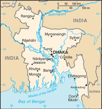
- Bangladesh is a low lying country in South Asia that is situated in the delta of the Ganges-Brahmaputra-Meghna confluences. Around 80% of the country is situated on the low-lying floodplain called the Bangladesh Plain.
- The country is prone to flooding and tropical monsoon conditions. Mahbub Alum said of Bangladesh in the International Journal of Climatology that Bangladesh is like a funnel, and combined with its low lying nature, makes even the most moderate of its annual monsoons potentially devastating.
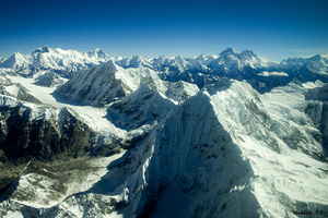
- The Ganges flows from the Himalayas down to the delta, and is influenced by snow and glacier melt.
- In 1998, abnormally high tides and high glacier melt contributed to prolonged monsoon rains in flooding the country.
- deforestation in nepal and river damming in india that had increased sedimentation also contributed to the flooding.
- The floods in Bangladesh in 1998 eclipsed the country's previous flooding disaster in 1988, lasting for nearly 3 months, instead of 3 weeks, compounded by continuing monsoon rains throughout the 3 month period.
Physical Causes of the flood
- Bangladesh sits in the Delta of the River Ganges, River Brahmaputra and River Meghna. The country is low-lying with 80%of the land just a metre above sea level.
- Prolonged heavy monsoon rains leading to all three major rives reaching peak flow at the same time.
- The Himalayas to the north of the country force relief (orographic rainfall), which increases rainfall totals and river levels.
- Tectonic activity in the Himalayas means that erosion rate in rivers is high. The eroded sediment is then deposited downstream in Bangladesh, chocking the river channels and increasing the chance of flooding.
Human Causes of the flooding
- Urbanisation on land prone to flooding.
- Deforestation in the himalayas reduced interception time, which shortened lag time and increased peak flow.
- The building of dams in India increased sedimentation in Bangladesh, which narrowed the channels.
- Pollution already in the rivers contributed to the flood. The Ganges is one of the most polluted rivers in the world, polluted by industrial waste, human waste and for religious regions, being one of the most sacred rivers in the world.
- Global warming has been attributed to increased snowmelt and higher sea levels.
Economic impacts of the flood
Environmental Impacts of the flood
Response
5 key points
- with 80% of the country under water, the immediate economic impact was extensive and wide-reaching.
- 700,000 hectares of crops destroyed.
- 400 factories closed.
- 20% reduction in economic production.
- 20 million made homeless.
- Two thirds of the country's capital city was under water for nearly three months.
- 2.04 million metric tonnes of rice crops lost.
Environmental Impacts of the flood
- One positive impact on the environment of the flood was an increase in soil fertility in the following years.
- 80% of the country's land under water.
- Pollution from the river, some of it toxic would have been spread across the land by the floodwater.
- 30 million made homeless
- Death toll = over 1000
- In response to the flood the Government of Bangladesh pledged to give free seed to farmers in an effort to kickstart agriculture.
- There were outbreaks of typhoid in some villages because of the poor sanitation and pollution in the river.
Response
- A number of ideas were proposed to prevent future flooding on the same scale, but due to lack of funding, were never properly put into practice. Idea included further damming upstream to hold more excess water and embankments built around Dhaka to contain the water.
- Volunteers and aid workers were left to repair the damage due to lack of funds.
- 350,000 tonnes of cereal given to the people by the government to help feed people.
- The United states of America donated a weather station to Bangladesh to help forecast future possible catastrophic floods to help better prepare the people
5 key points
- Response to the flood was reactive rather than proactive, as is the case in many LEDCs when compared to MEDCs, it was however reliant on international aid and there was not the necessary funding to ensure safety from future flooding.
- This has been described as a one in 50 year event, and the country had previously suffered from severe flooding just 10 years earlier in 1988, yet was still underprepared.
- A potent mix of physical and human factors leave Bangladesh susceptible to huge flooding events.
- There has been a large flooding event since, in 2007 which proves that the country's flood defences are still inadequate even in more recent years.
- Despite the official death toll being relatively low for an LEDC disaster, the displacement of 30 million people from their homes highlights a lack of robust infrastructure in the country in the face of an event such as this.
