Erosional Landforms
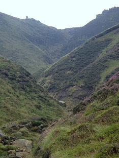
V-shaped valleys and interlocking spurs
Waterfalls and rapids
- In the upper course of the river, the large sediment such as boulders and cobbles can only be moved after period of heavy rain or snowmelt.
- When they are transported they are bounced and rolled along the bed causing vertical erosion.
- This produces a steep-sided v-shaped valley. The shape of the valley is dictated by climate, the more rainfall there is, the higher the discharge and erosion rates; geology, the rock structure affects the shape; and vegetation, the more vegetated slopes have more stable soil and valley sides.
- As the river begins to wind to avoid areas of hard rock it forms protrusions of land known as spurs. Looking up the valley these can appear to interlock, as per the image to the left.
- When glacial erosion subsequently occurs through the valley, this can sometimes leave behind truncated spurs.
Waterfalls and rapids
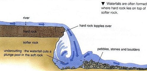
- Waterfalls occur when there are rapid changes in the gradient of the river's cause.
- They occur where there is a marked difference in geoglogy, where resistant rocks are underlain by softer ones. The force of the water will erode the softer rocks creating a plunge pool, which undercuts the resistant rock layer, leading to collapse.
- Using this method, the waterfall will retreat up the valley, and often leave a gorge behind.
- Rapids and waterfalls are both common in the upper course of a river due to the steeper gradients and variety in rock strength.
Depositional Landforms
Floodplains - The land adjacent to the river which is often fertile due to the river depositing sediment when it floods.
Levees- Levees are formed when a river floods and drops the heavier, courser material closer to its banks. This develops into parallel banks of sediment that line the river. In some places these are artificially strengthened to provide flood defences.
Braiding - Occurs when the channel has high sediment loads, but due to climate or topological conditions, lose energy rapidly. This causes sudden deposition which can block the channel. The main river channel then divides into smaller channels that diverge and converge as they find easier routes through the sediment.
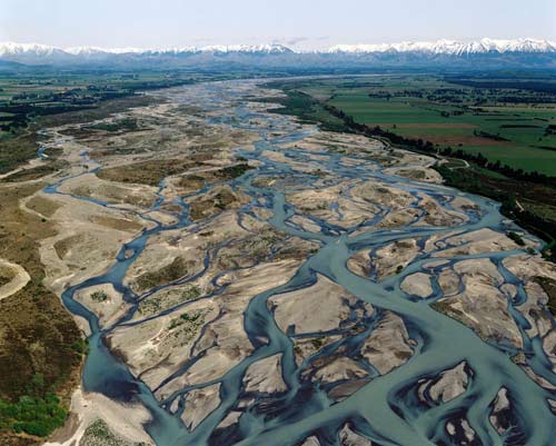
A braided channel
Deltas - Areas of deposited sediment at the mouth of the river. They provide fertile land and are associated with oil and gas deposits beneath the surface. They are however inherently unstable because of the nature of their composition.
Meanders and Oxbow Lakes - Because of the nature of rivers, that they are all flowing downhill through the path of least resistance, changes in geology and topography rarely means that path is straight. This link describes in detail how meanders and Oxbow Lakes are formed, in detail:
http://www.wiley.com/college/strahler/0471480533/animations/ch17_animations/animation1.html
