Definition: |
The Long profile of a river charts the change in altitude from source to mouth. The profile is concave as the slope becomes gentler towards the mouth of the river. A long profile will also chart different landforms found a long the course of a river.
|
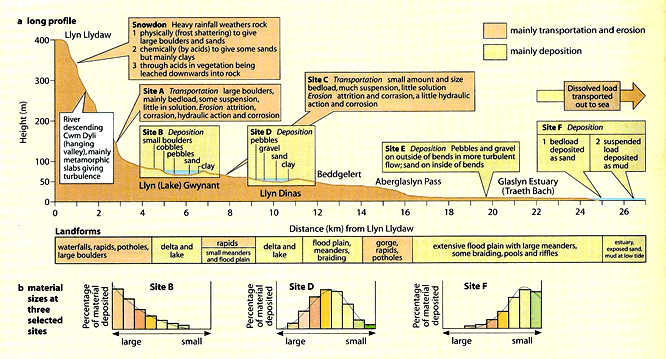
The above diagram is a detailed example of a long profile for the river Thalweg in Wales and is taken from the AQA AS level geography textbook.
The diagram demonstrates that erosion closer to the source of the river is more likely to deposit large boulders. Further downstream, midway through the course of the river, there are a mix of grain sizes in a rivers deposition, whereas at the mouth of the river, deposited material tends to be fine sediments. The dissolved load of the river - the finest sediment is carried out to sea.
The diagram demonstrates that erosion closer to the source of the river is more likely to deposit large boulders. Further downstream, midway through the course of the river, there are a mix of grain sizes in a rivers deposition, whereas at the mouth of the river, deposited material tends to be fine sediments. The dissolved load of the river - the finest sediment is carried out to sea.
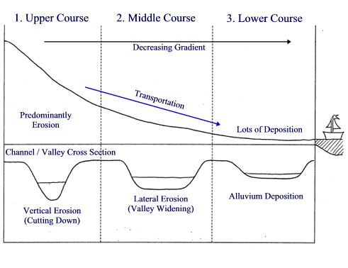
- The long profile of the river can be split into three main sections, the upper course, the middle course and the lower course, as the above diagram shows.
- Upper Course - often flows through a steep sided valley with a narrow channel. Waterfalls, lakes, potholes, and gorges are common features that can be found in the upper course of a river. The main processes in action through the upper course of the river are vertical erosion by hydraulic action and attrition. During heavy rainstorms, large boulders can be transported.
- Middle Course - through the middle course of the river, the steep sided valleys are eroded and widened as the flood plain begins to develop. The river forms meanders and river cliffs. Attrition is the most common form of erosion here as traction and suspended load increases while the gradient of the river becomes increasingly smooth. As more water joins the channel through surface flow, throughflow and tributaries the channel widens.
- Lower Course - The lower course of the river is the river's widest generally. Levees, large meanders and floodplains are common characteristics. Erosion is lateral on the outside of meanders and the sediment is often small bed load such as sand transported in suspension.
Key Terms
- Attrition: A process of erosion whereby rocks being transported downstream along the riverbed are involved in regular collisions with the riverbed.
- Hydraulic Action: The constant movement of water against a riverbed has the ability to dislodge and transport rocks and sediment.
- Traction: The movement of larger eroded particles along the bottom of the river.
- Suspended Load: River load is physical matter carried by the water. Suspended load is the smaller eroded particles that are carried along by the river. They are too large to be dissolved but too small to fall to the river bed.
- Levees: Natural levees are formed in the lower course of a river due to a high amount of of suspended sediment deposition. They are defined as elongated banks of silt and mud that form on the river's floodplains.
